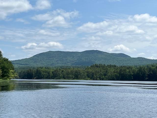
Crotched Mountain dominates the landscape of Bennington, and when viewed from across Powder Mill Pond, it is quite impressive. Like several other local peaks, it can be called a ‘monadnock’, which means a mountian that is not surrounded by others of equal size. It is because of Crotched Mountain that Bennington was the last town in the area to be settled due to the rugged terrain.
When we look at the rocks that form Crotched Mountain, and the minerals in the rocks, they can tell quite a story. The mountain is made of two metamorphic rocks that demonstrate great changes over quite a lot of time – a v-e-r-y long time.
Somewhere along the line, about 460 million years ago, during the Ordovician Period of the earth’s history, what would become New Hampshire was covered by a shallow ocean in which many layers of sand, silt, and clay were being deposited by rivers flowing into the ocean. Then, around 430 million years ago, the part of the crust carrying what would become Europe moved toward the crust carrying future North America. That event caused the crust under those layers of sediments to crack into faults. Ever notice the little earth-quakes we get in New Hampshire? They are caused by small motions along those many faults.
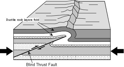
When parts of the Earth’s crust are compressed, there are several options: parts of the crust can move up; parts of the crust can move down; or parts of the crust can slide under other parts. The last example is called a Thrust Fault, and south-eastern New Hampshire is the location of many faults. As the south-eastern part of the state was pushed under the south-central part of the state, a high ridge formed, running from Henniker to Massachusetts.
Rocks and other Earth materials can change. Just as a potter takes soft clay and heats it in a kiln to make it into hard ceramic, so the heat and pressure of that ridge formation caused the sand to turn to quartz crystals, and the silt to metamorphose, or change, into biotite and muscovite micas. The presence of the minerals garnet and sillimanite tell us that there was a lot of pressure, which caused very high temperatures – from 900 to 1200 degrees Celcius. The ridge at the time might have stood many thousands of feet high, much higher than the Monadnock area peaks today.

A metamorphic rock called Schist is the type of rock that makes up Crotched Mountain. It went from being loose sediment to a ridge of solid rock. Over time, weathering and erosion carved the ridge into the separate mountains that became the Wapack Range – Temple Mountain, Pack Monadnock, Mount Monadnock, Crotched Mountain, Pats Peak, and Lovell Mountian.
Then 2.4 million years ago, the glaciers of the Ice Age began to move through the area. Four times the ice moved across the region, wearing down the high places, digging valleys, and filling low areas with sand and gravel. The Ice Age ended around 11,000 years ago. As the mountain peaks were worn down, rocks that had been deep under ground were exposed at the top. Imagine laminating two different woods together, one on top of the other. If you sanded too long in one spot, the lower wood would show through.

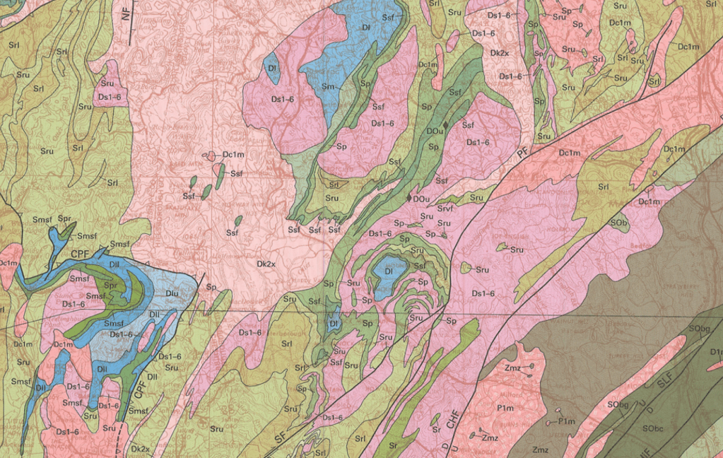
This close-up of the Geologic Map, shows Crotched Mountain in the lower right corner. The slopes of the mountain are made up of the Rangely upper member [rock Sru, shown in green] and at the top of the mountain, the older Rangely lower member [rock Srl, shown in lavender] peeks through.
At the top of Crotched Mountain, an older rock called “Rangely Formation, lower member” [shown on geologic maps as ‘Srl’]*, runs as outcrops along the ridge. This rock contains quartz, muscovite mica, and biotite mica. Around it, “Rangely Formation, upper member” [seen on the map as ‘Sru’]*, covers the sides of the mountian. The fact that there are two different rocks allowed more erosion by glaciers at the interface [contact] of the two rocks. This is why Crotched Mountain has its distinctive notch. Early settlers thought it looked like the crotch of a tree, where a branch meets the trunk, thus “Crotched Mountain”.
And that is the history of the mountain named Crotched, 460 million years in the making.
*Srl stands for Silurian, Rangely, lower. Sru stands for Silurian, Rangely, upper.
The next installment of the Bennington NH Historical Society Blog will be posted on 19 August, 2025. If you click the Subscribe button, all future posts will be sent straight to your inbox every month – for free.
