Every town needs a Town Hall — where administrative work is carried out, perhaps where voting is held. Bennington, NH was incorporated in 1842, but the town lacked the appropriate civic structure until 1881. In the earliest days of Bennington, meetings were held in taverns, in private homes, or in a church. The largest and only church in town in 1843 was the Baptist Church, and that is where the first Town Meeting was held on January 13.
As the town increased in population and prosperity, the idea was proposed at Town Meeting to build a real Town Hall. It was put to a vote in 1844, ’49, ’50, ’54, ’56, and ’57 — but each time it was tabled or voted down. ‘Seems that becoming their own town was more expensive than people had thought it would be. After building bridges and roads and buying land for Sunnyside Cemetery, taxes went up and interest in new infrastructure went down.
The Civil War incurred more expenses for Bennington, so the project was put off. By the late 1860s, citizens began to be chagrined by their lack of a Town Hall. At the 1870 Town Meeting, only 35 of the 135 registered voters [all of them men] turned up for the discussions. Twenty-six of them voted ‘aye’ to set up a committee to look into building a Hall. The following July, a vote was held to see if the voters would approve $1,500. It passed, but was soon and often challenged. Finally, in March of 1871, the matter was decided: the people wanted a Town Hall, and they would pay to have it built.
A location at the East end of the main bridge near the center of the Village was chosen as the site. By September, the splendid building in the Italianate Style was open for business. It had cost $3,800. Part was paid by the town, part was paid by School Districts #1 and #2. More about that later…..
The next installment of the Bennington NH Historical Society Blog will be posted on February 16, 2026. If you click the Subscribe button, all future posts will be sent straight to your inbox every month – for free.
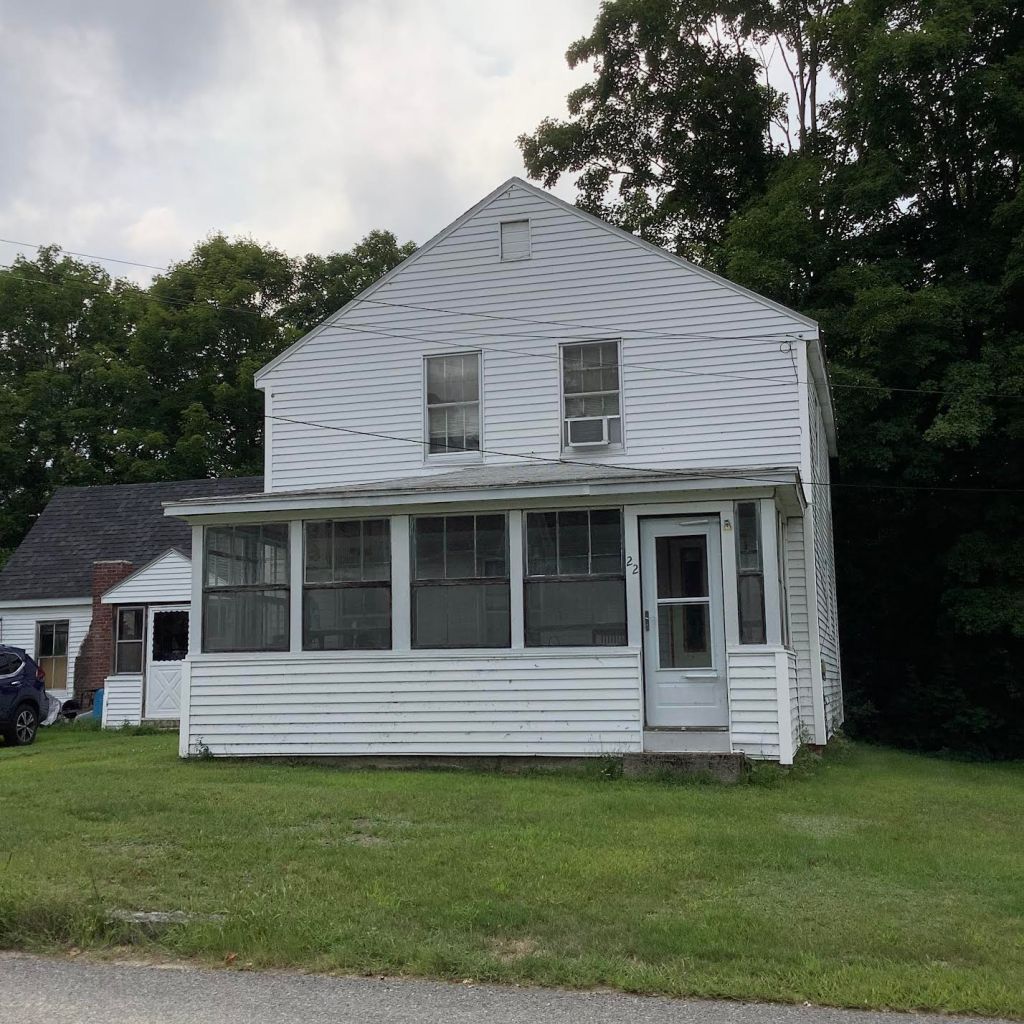
One can tell a lot about the economic history of a community by looking at the houses. If one style predominates, that reveals when the fortunes of the town were at their peak. Architecture styles change over time, showing the preferences of the people based on convenience, availability of materials, and outside influences. Bennington is no different, as 10 distinct styles were employed from late 1700s to the 1950s: the Cape; the Colonial; the Federal; the Gable-Front; Gothic Revival; Italianate; attached barn; Second Empire; Queen Anne; and the Ranch.
In the mid-1800s, a new building style emerged. Architect Alexander Jackson Davis had written books about house construction from 1830-1850. Whereas previous buildings had been inspired by Greek or Roman sources, Davis suggested something of a medieval style. The pointed windows and steep roofs of the Gothic Revival were popular for a while, before they were supplanted by the next cultural fashion. Some say that the Gable-Front House is influenced by the Gothic Revival, with its pointed gable facing the street, but that might be a coincidence. Another name for this style is Victorian Gothic. The house in the background of Grant Wood’s famous painting “American Gothic” is built in the Gothic style.
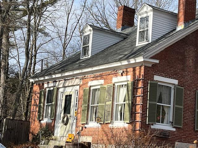
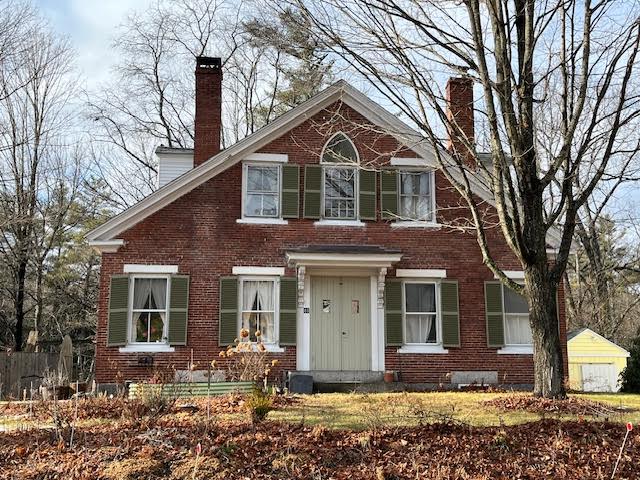
In truth, there is no real example of a Gothic Revival house in Bennington. But there is one dwelling that shows how styles evolve, even within the same structure. Where Mill Street/Antrim Road meets Main Street, next to the Historical Society, there is a brick house. It was built as a Cape in the early decades of the 1800s, facing South, at right angles to the road. The front door has Federal side-lights, maybe original, maybe added later, reflecting yet another style.
Mid-century, a door was added on the street-facing wall, turning the house into a Gable-Front. Above the door on the gable side is a window — but not just any window. The pointed arch of the window [typical of Medieval church architecture] shows that it was designed with Gothic Revival in mind.
Over 50 years, the owners of the house responded to changing fashion four times! “Keeping up with the Jones”, and keeping up with the times!
Promo: The next installment of the Bennington NH Historical Society Blog will be posted on January 19, 2026. If you click the Subscribe button, all future posts will be sent straight to your inbox every month – for free.
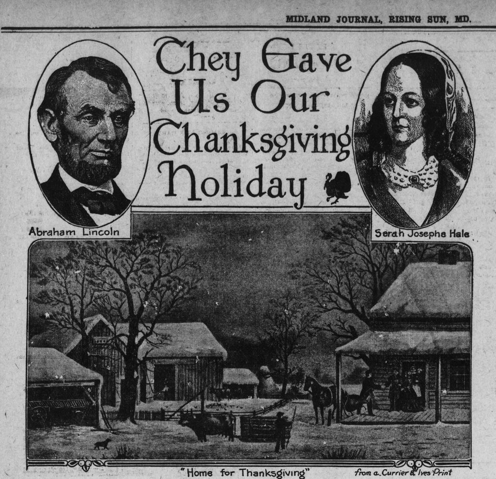
Did you know that the American Thanksgiving was ‘created’ by a New Hampshire woman? You might have been taught that it was first celebrated in Plymouth, Massachusetts — Pilgrims and Indians and all that. But that was a one-off observance of an English tradition. The true American Thanksgiving is from New Hampshire.
Sarah Josepha Buell Hale, born in Newport, was a style-maven of the 1800s. She was the editor of the popular Godey’s Ladies’ Book, published in Boston. Hale balanced work demands with raising a family as a single mother — a ‘modern’ woman if ever there was one! She was an influencer with millions of devoted ‘followers’, like the Martha Stuart of her day. In 1827, Hale wrote a novel, Northwood: Life North and South, in which she describes a ‘typical’ upper-middle class New Hampshire family celebrating a Thanksgiving meal.
Starting in 1846, Hale lobbied for a national holiday of Thanksgiving. At that time, such an event was sporadically popular in New England, but Hale thought that the entire nation should celebrate it. During the Civil War, she wrote several letters to President Lincoln urging him to declare such a holiday, in an effort toward national unity. If everyone had a holiday in common, Hale reasoned, then maybe they could agree on bigger issues too. Finally, in 1863, Lincoln decreed “A National Day of Thanksgiving and Praise”, in response to Hale’s urging. That is why the illustration at the top of this page states “They gave us our Thanksgiving Holiday”.
PS: Sarah Josepha Buell Hale also wrote “Mary Had A Little Lamb”.
The next installment of the Bennington NH Historical Society Blog will be posted on January 19, 2025. If you click the Subscribe button, all future posts will be sent straight to your inbox every month – for free.
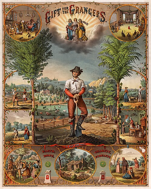
Have you heard of The National Grange of the Order of Patrons of Husbandry? Probably not, but you might recognize its common name: The Grange. The name is from the French word for “barn”, a necessary outbuilding on every farm. The Grange was formed in 1868, following a tour of the American South by a commissioner tasked by President Andrew Johnson to look into agricultural practices on small farms. Oliver Kelley visited farms in the former Confederate States and also in the territories and new states of the Midwest. He was horrified by farmers’ lack of knowledge about ‘progressive agriculture’. Kelley thought that if there were a national organization of farmers, that they could trade information and best practices to improve farm output and profits. Through the work of likeminded people, Grange #1 was established in Fredonia, New York. The group went national in 1873, with an office in the nation’s capital. From its start, the Grange was egalitarian, recognizing the work of women and teenagers on the farm. Every Grange was required to have at least four women among its elected officials, and teenaged boys ‘old enough to push a plow’ were permitted to join.
On January 8, 1894, the Bennington Grange was founded. The 24 founders met, with rituals and secret passwords, at the Town Hall. Ten year later, the group was much larger and wanted their own building. After fundraising, they bought the one-story building where Harmon Larkin had sold jewelry and repaired clocks since the 1850s. Members quickly began to fund-raise to enlarge the house to two floors. In their new hall, they held meetings and banquets, often lasting into the wee hours of the morning. A “Neighbors’ Night” might see 100 people dining following a literary program. Grange members not only promoted modern farming, they were a major part of the social fabric of the town. They sponsored patriotic celebrations, lawn parties in the summer, and theatrical performances at the Town Hall.
Membership waned after WW2, as there were fewer farms in Bennington, and families could find entertainment outside of town. In the 1970s, the local chapter dissolved and members merged with the Antrim Grange. In the early 1980s, the building was purposed for a pre-school/day care called Small Beginnings. Currently, the building is a two-unit dwelling.
The next installment of the Bennington NH Historical Society Blog will be posted on October 20, 2025. If you click the Subscribe button, all future posts will be sent straight to your inbox every month – for free.
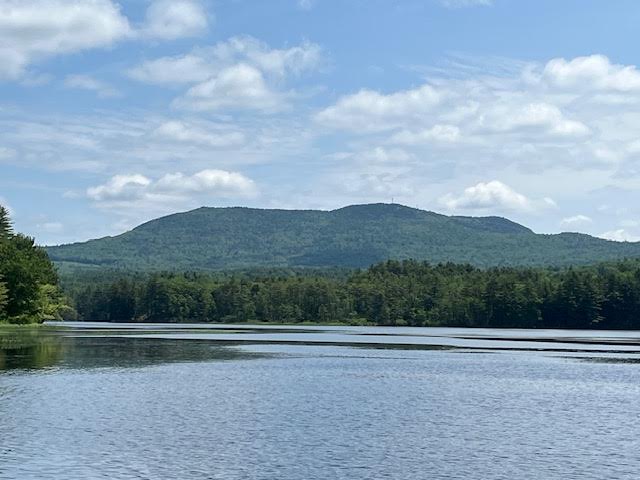
Crotched Mountain dominates the landscape of Bennington, and when viewed from across Powder Mill Pond, it is quite impressive. Like several other local peaks, it can be called a ‘monadnock’, which means a mountian that is not surrounded by others of equal size. It is because of Crotched Mountain that Bennington was the last town in the area to be settled due to the rugged terrain.
When we look at the rocks that form Crotched Mountain, and the minerals in the rocks, they can tell quite a story. The mountain is made of two metamorphic rocks that demonstrate great changes over quite a lot of time – a v-e-r-y long time.
Somewhere along the line, about 460 million years ago, during the Ordovician Period of the earth’s history, what would become New Hampshire was covered by a shallow ocean in which many layers of sand, silt, and clay were being deposited by rivers flowing into the ocean. Then, around 430 million years ago, the part of the crust carrying what would become Europe moved toward the crust carrying future North America. That event caused the crust under those layers of sediments to crack into faults. Ever notice the little earth-quakes we get in New Hampshire? They are caused by small motions along those many faults.
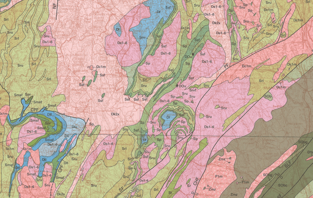
On this geologic map of New Hampshire, the colors show the locations of different rocks of different ages. You can see how the colors are swirled together, like batters in a marble cake. That happened when the crust compressed and folded the rocks upon eachother. The black lines running upper right to lower left are faults, or breaks in the crust.
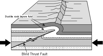
When parts of the Earth’s crust are compressed, there are several options: parts of the crust can move up; parts of the crust can move down; or parts of the crust can slide under other parts. The last example is called a Thrust Fault, and south-eastern New Hampshire is the location of many faults. As the south-eastern part of the state was pushed under the south-central part of the state, a high ridge formed, running from Henniker to Massachusetts.
Rocks and other Earth materials can change. Just as a potter takes soft clay and heats it in a kiln to make it into hard ceramic, so the heat and pressure of that ridge formation caused the sand to turn to quartz crystals, and the silt to metamorphose, or change, into biotite and muscovite micas. The presence of the minerals garnet and sillimanite tell us that there was a lot of pressure, which caused very high temperatures – from 900 to 1200 degrees Celcius. The ridge at the time might have stood many thousands of feet high, much higher than the Monadnock area peaks today.
The darker minerals are biotite mica. The lighter spots are quartz. The reddish blobs on the right-hand rock are garnets.
A metamorphic rock called Schist is the type of rock that makes up Crotched Mountain. It went from being loose sediment to a ridge of solid rock. Over time, weathering and erosion carved the ridge into the separate mountains that became the Wapack Range – Temple Mountain, Pack Monadnock, Mount Monadnock, Crotched Mountain, Pats Peak, and Lovell Mountian.
Then 2.4 million years ago, the glaciers of the Ice Age began to move through the area. Four times the ice moved across the region, wearing down the high places, digging valleys, and filling low areas with sand and gravel. The Ice Age ended around 11,000 years ago. As the mountain peaks were worn down, rocks that had been deep under ground were exposed at the top. Imagine laminating two different woods together, one on top of the other. If you sanded too long in one spot, the lower wood would show through.
This close-up of the Geologic Map, shows Crotched Mountain in the lower right corner. The slopes of the mountain are made up of the Rangely upper member [rock Sru, shown in green] and at the top of the mountain, the older Rangely lower member [rock Srl, shown in lavender] peeks through.
At the top of Crotched Mountain, an older rock called “Rangely Formation, lower member” [shown on geologic maps as ‘Srl’]*, runs as outcrops along the ridge. This rock contains quartz, muscovite mica, and biotite mica. Around it, “Rangely Formation, upper member” [seen on the map as ‘Sru’]*, covers the sides of the mountian. The fact that there are two different rocks allowed more erosion by glaciers at the interface [contact] of the two rocks. This is why Crotched Mountain has its distinctive notch. Early settlers thought it looked like the crotch of a tree, where a branch meets the trunk, thus “Crotched Mountain”.
And that is the history of the mountain named Crotched, 460 million years in the making.
*Srl stands for Silurian, Rangely, lower. Sru stands for Silurian, Rangely, upper.
The next installment of the Bennington NH Historical Society Blog will be posted on 19 August, 2025. If you click the Subscribe button, all future posts will be sent straight to your inbox every month – for free.
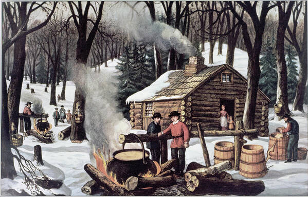
As winter days grow longer, the trees know that Spring is coming, and the sap starts to rise. When colonizing settlers first arrived in New England, they had never heard of maple syrup. The Abenaki People had invented the process of turning maple sap into maple syrup generations ago, and they taught the new-comers the process. Sugar from the Caribbean was an expensive commodity in New Hampshire, so settlers took to making their own sugar from maple sap.
“Maple Sugaring”, a print by Currier & Ives
In the early 1800s, farmers and townspeople alike would plant sugar maples close to the house to make the process easier. Look for a row of old maples alongside a country road, or arranged around a Colonial or Federal-style house — those were put there on purpose by a canny long-dead resident to have a convenient source of maple sap. Otherwise the home-owner would have to range through the forest to find enough trees to tap. During the Civil War, this became an act of Northern solidarity, since the sugar made from sugar cane was produced with slave labor.
To make syrup, 40 gallons of sap — preferably from Sugar Maples, Acer saccharum — are boiled down to yield one gallon of syrup. To supply a family’s needs took a lot of sap and a lot of firewood. If the boiling is continued past the syrup point, the sugar will begin to crystalize, and come out of the solution. “First run” sap produces a light-colored, mildly-flavored syrup and sugar, compared to the syrup that the tree produces weeks later, and thus the early run was more highly prized. Sap season lasts around four weeks.
Maple syrup was used as a sweetener in baking, and of course to put on griddle cakes and bread. Maple sugar was used as a sweetener in beverages, and for dusting over a cake for decoration. Many farms that took in summer visitors would sell maple sugar candy or syrup to their guests. Those products were also useful for barter.
The next installment of the Bennington NH Historical Society Blog will be posted on March 25, 2025. If you click the Subscribe button, all future posts will be sent straight to your inbox every month – for free.
Residents of Bennington refer to the center of the town as “The Village”. This was the original settlement of the town, where the houses and mills were located around 1800. The population moved into areas outside the Village as farms became established away from the river. But the river defined the town and the river needed a bridge.
When Joseph Putnam moved to Bennington and set up his water-powered saw mill, he built a wooden bridge across the Contoocook. Like the house of the Second Little Pig in the children’s story, wood is not the most suitable material for a bridge: either the water rots it or it is washed away in a flood.
Within 10 years of building his first bridge, Putnam solicited help from the Town of Hancock to build a new one. He made a deal to join his land on the right bank of the river with Hancock on the left bank. This done, the bridge would be the responsibility of Hancock’s citizens to pay for it. They dragged their feet for five years, and at last a wooden bridge with stone abutments was completed in 1799.
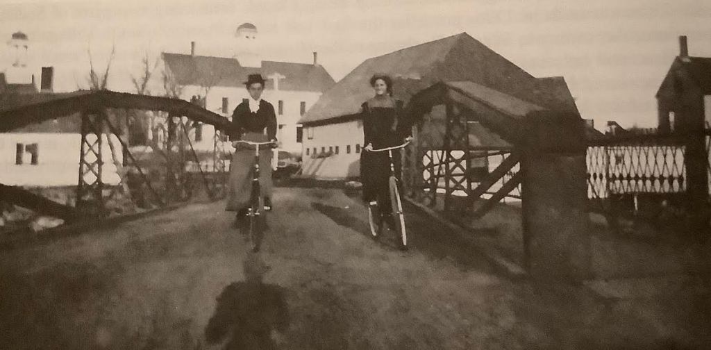
That bridge was destroyed by successive Spring floods in the 1880s. A special town meeting was gathered in 1886, “to see what kind of a bridge the town will vote to build…” They elected to buy a pre-fab iron bridge from the Berlin [Connecticut] Iron Bridge Company for $1559.31. It had a footbridge on the upstream side with a railing.
Merry cyclists cross the 1886 bridge in style. Attached footbridge is seen on right.
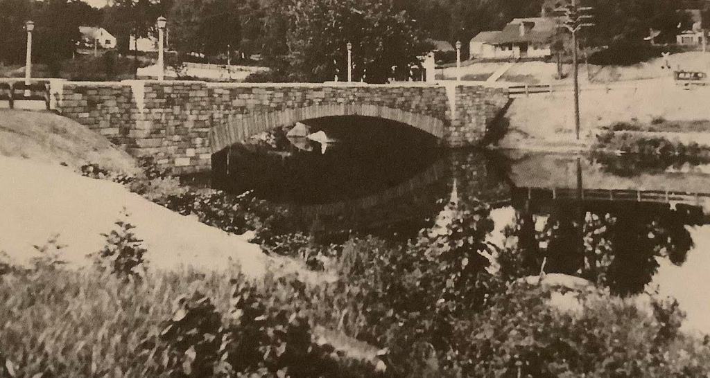
That bridge was still standing in the early 1930s. In 1935, in an effort to employ the millions of people impoverished by the Great Depression, the US government established the Works Progress Administration. The town applied to upgrade the bridge and the approaches to it, and in 1934, a new structure appeared: a single arch span of New Hampshire granite. The road and bridge surface were widened to accommodate cars and trucks. Houses were moved out of the way, as was the Bennington Railroad station.
The bridge is still in use, festooned with greenery in the winter and decked with flowering baskets in the summer. It does its job well.
The next installment of the Bennington NH Historical Society Blog will be posted on December 17, 2024. If you click the Subscribe button, all future posts will be sent straight to your inbox every month – for free.
An historian asks, “What happened on a particular day – a battle? The death of a king?” The social historian asks, “What did people do on that day – what did they wear? What did they eat?”
Today we will answer the question, “What did people drink in Bennington?” We know that people were living within the boundaries of the present town as early as 1782, so we will take that as a starting place. My references for this foray into the past include: Tea With Jane Austin; the two Town histories and Colonial Spirits.
As we saw last month, there were many non-alcoholic beverages available to early residents. Do not think that our early residents were teetotalers: alcoholic beverages were part of daily life. The Farm Wife had to be well-versed in turning plant matter into beverages: for family consumption, to supply to hired hands, to serve to guests, to preserve the harvest, and for medicinal use.
>>Gruet is an ancient fermented mixture made from herbs and grains but no hops. It is a light, refreshing alcoholic beverage with a short storage life. It would be made and served at home during the summer when the flavoring herbs were ripe.
>>Beer was consumed in vast quantities all day long. This was in keeping with traditions from the Old Country. When we read today about a man of that era drinking a gallon of beer a day, it sounds shocking. But you should know that the alcohol content was very low: 1-2.5% — practically water! Beer was made at home and also at taverns and public houses. With the addition of hops, beer could keep for months.
>>Cider was a very important beverage in early times. By 1800, apple trees had become well-established and their fruit was needed to make the mildly alcoholic drink we refer to today as ‘hard cider.’ Cider is very easy to make and was put up in barrels to last the family through the year. The alcohol content was 3.5-4%. In the winter, the cider barrels would freeze – except for the alcohol portion. Teenage boys would sneak out to the shed and get schnonkered on the highly intoxicating liquid. Cider was usually of the ‘still’ variety, not the bubbly cider more popular today.
>>Apple jack is distilled cider. Distilling was a common home activity to make small quantities of medicinal alcohol necessary for preparing tinctures. Most farm wives had a distillation apparatus and they took pride in preparing liqueurs and other distilled delights. A gallon or two of apple jack would be doled out for celebrations or as medicine for its stimulating effect.
>>Wine from Europe could be purchased at great expense in port cities, but it is unlikely that even the most wealthy Bennington citizens were drinking it until the later 1800s. Local people could make do with home-made wine. So-called ‘country wines,’ they were not made from wine grapes but from local fruits. If the Good Wife sent the children out to pick wild fruit, some of it went into pies and jellies and lots of it went into wine. Wine would be served socially and also used for medicinal purposes. “Take a little wine for the stomach’s sake,” said Saint Paul to Saint Timothy.
>>And then there is rum. Made with molasses from the Triangle Trade, rum could be purchased at the tavern or even at Whittamore’s general store. Making rum oneself was not a common practice since it took ingredients in quantities not found at home. Rum was in punch, in cocktails [they go back to the 1700s], and sometimes drunk straight up. Rum was used to influence voting all over the 13 Colonies as ‘vote buyers’ would bribe people with liquor to vote early and often for their candidate.
Rum in those days was a rather nasty beverage. To temper its harsh flavor, many other ingredients were added. A typical drink of the era might have been a Cold Flip. It contained rum, molasses, salt, a raw egg, and brown ale all shaken together and topped with nutmeg. Then there was Regent’s Punch, made of tea, rum, wine, and fruits.
The next installment of the Bennington NH Historical Society Blog will be posted on November 11, 2024. If you click the Subscribe button, all future posts will be sent straight to your inbox every month – for free.
An historian asks, “What happened on a particular day – a battle? The death of a king?”
The social historian asks, “What did people do on that day – what did they wear? What did they eat?”
Today we will answer the question, “What did people drink in Bennington?” We know that people were living within the boundaries of the present town as early as 1782, so we will take that as a starting place. My references for this foray into the past include: Tea With Jane Austin; the two Town histories and Colonial Spirits.
>>“Adam’s Ale”, as water has been called, was not uncommon as a beverage. Living on the river made fresh water very accessible. The hill farms had to rely on dug wells, but the water in town was good to drink. It is popularly said that Colonial-era people drank beer because the water was unhealthy. That was true in European cities, but not in early small-town New England, until industrial pollution made the water unsafe.
>>Tea from England was expensive and had been a bone of contention during the revolutionary war, so it is unlikely that early residents of Bennington drank much tea. Tea leaves were expensive, so they would have been steeped over and over to wring all the flavor from them. The alter-natives were herbal teas from such sources as raspberry leaves or bergamot. These were considered inferior but patriotic. Herbal teas were also used as medicines. Tea also found its way into drinks that packed a bigger punch, as we will see later.
>>Coffee would have made its way into local stores by mid-1800.
>>Sumac ‘Lemonade’ was made from the red clusters found on Staghorn and Smooth Sumac in late Summer. Soaked in hot water, then strained, the tart liquid was sweetened with honey or maple syrup to make a pleasant beverage. This knowledge came from the Indigenous People of the area.
>>For the farmer or laborer toiling in the hot sun, Switchel was considered the best thirst-quencher. Made of water sweetened with molasses or honey, the most important ingredient was cider vinegar or sometimes rum. Pitchers of cool switchel were a boon to the hay-making crew.
>>In Autumn, apples would be pressed into cider. While the season lasted, cider was a delightful drink, just as it is now.
The next installment of the Bennington NH Historical Society Blog will be posted on October 14, 2024. If you click the Subscribe button, all future posts will be sent straight to your inbox every month – for free.
One can tell a lot about the economic history of a community by looking at the houses. If one style predominates, that reveals when the fortunes of the town were at their peak. Architecture styles change over time, showing the preferences of the people based on convenience, availability of materials, and outside influences. Bennington is no different, as eight distinct styles were employed from late 1700s to the 1950s: the Cape; the Colonial; the Federal; the Gable-Front; Gothic Revival; Italianate; attached barn; Second Empire; Queen Anne; and the Ranch.
In the old days, people built houses with one of two orientations: front door/long axis facing the road, or front door facing South, to maximize sunlight and winter warmth. From around 1830, a major change in orientation occurred, resulting in the Gable-Front House.
Two factors went into this shift: lot size and the Greek Revival. As town populations grew, previously large lots were divided. Some of the resulting lots were too narrow to build a Cape or Federal, so the house was rotated 90 degrees, causing its gable end to face the front. The style quickly became popular in urban areas. Furthermore, early in the 1800s, with the discovery of Pompeii, interest about Classical architecture grew. Houses with the gable facing the road became the next new thing — very fashionable.
Going away from the Village on Bible Hill Road, we see Gable-Fronts.Also on Bible Hill Road, another example, with a bit less symmetry.
Typically, the house had 2.5 stories and was one or two rooms deep. The front door was on the left or the right, along with two windows downstairs and three windows upstairs. The gable roof line is strongly reminiscent of the pediment on a Greek temple.
This Acre Street version has only two windows upstairs.This Acre Street version adds a front porch.
The style was popular throughout the 1800s and into the early 1900s, since it could be constructed as a large, stately house or as a smaller, humble dwelling. It was often the base style for subsequent add-ons in the later part of the century, as we shall see in a future post.
A stately house on Mill Street has a Gable-Front.A Worker’s House on Starret Road has a Gable-Front
The next installment of the Bennington NH Historical Society Blog will be posted on September 16, 2024. If you click the Subscribe button, all future posts will be sent straight to your inbox every month – for free.