Hancock was founded in 1779, Francestown in 1772. Then there’s Antrim in 1777. So how come Bennington didn’t become a town until 1842?
Come back in time with me to the early 1600s, and I’ll tell you the story… As you read, count up how many different names the place now known as ‘Bennington’ has had in the past.
John Mason, of England, was very interested in the New World. In 1620, King James I drew lines on a map of North America and gave a large chunk to Captain Mason. This property ran from Cape Ann, Massachusetts to the Merrimack River. He named it “Mariana.” By the time of his death in 1635, Mason had a claim to extensive lands in New Hampshire, from the ocean to the sources of the Piscataqua and Merrimack Rivers.
For the next hundred years, his claim was fought over in endless title disagreements until a group who called themselves the Masonian Proprietors bought a clear title from Captain Mason’s son, John Tufton Mason, in 1746. Much of the land in southern New Hampshire had been divided into towns by then, except for an area on both sides of the Contoocook River. They called that region “Company Land” or “Society Land.”
These men were land speculators: they bought up land so they could sell it for a profit. Already 35 towns had been formed from Mason’s original land. As they poured over the maps, the Proprietors saw that one area was still unsettled. It was on the river, and that was a plus, but the land was rugged. Being dominated by a tall mountain, the parcel was not great for farming.
The Proprietors divided this remaining land among themselves, into fifteen plots which ranged from 500 acres to 1000 acres. By the 1770s, European settlers felt that it was safe enough to move into this area. Francestown was established in 1772, and named after colonial Governor Wentworth’s wife Frances. Deering, named for Frances Wentworth’s middle name, came next in 1774. As the Revolution seethed, Scots-Irish residents in Society Land formed Antrim in 1777.
The rushing, tumbling falls of the Contoocook River presented a problem to settlement which no one could bridge. When Hancock was granted the rights of a town, its border was the River. Land east of the River was yet unsettled. As the 1800s dawned, the only remaining part of Society Land which was not a town was a small area between Crotched Mountain, Francestown, and the River. This had been called “Great Lot Number Nine” when the land was divided among the owners of Society Land.
The first European settler in our town was Joseph Putnam who arrived in the Fall of 1782. His family had founded Wilton and Lyndeboro, and now Joseph was looking for a site for a water-powered saw mill to provide lumber to the new population. He bought the title to the land from his brother who had been the first European to visit the Falls. Soon, he built a house where Pierce School is now, having a farm, a dam, a saw mill, and a grist mill. He bought more land and the water rights to the river, and most importantly, he built a wooden footbridge to the Hancock side of the river. Before 1800, 12 or more other families settled in what was known as Putnam’s Mills. These families included Colby, Dodge, Huntington, Parker, Wilson, and Eaton, to drop a few familiar names.
The population waxed and waned but never really grew much due to Putnam’s exclusive property rights. Although there were no more than 30 families, they elected selectmen, appointed constables, and held town meetings at Putnam’s house. From 1785 on, petitions were made to the State Legislature to incorporate or to join neighboring towns. Putnam and his land joined Hancock prior to his leaving the area. This created problems for the remaining residents: no local church, no town hall, no local school, no local post office, no businesses except family farms.
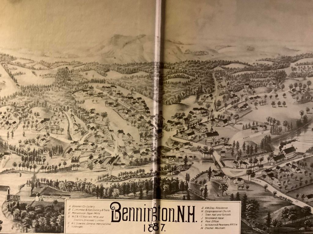
But after Putnam left, new mills and industries grew up along the river, run by the Whittemores and the Burtts. This attracted a greater population to work in the cotton mills, the saw mills, the hotel, the woolen mill, the fulling mill. The area, still part of Hancock, was then called Hancock Factory Village. Home industries included paper making and gunpowder manufacturing. The first church was built in 1826, and the town had a building boom in the 1830s. New roads and new bridges lead new people into the not-yet-a-town.
In 1842, after simmering disputes with Hancock over school, liquor laws, and feeling like second-class citizens, John Huntington asked the State Legislature for an independent town of their own. Hancock voted against this at their next Town Meeting, but that did not stop the rising tide of secession. To make the town boundaries large enough to qualify as a town, parts of Antrim, Francestown, Deering, Greenfield, and Hancock were shaved off. At last, on December 15, 1842, Bennington was incorporated as the newest town in New Hampshire.
Why was it called “Bennington”? Was it after Governor John Benning Wentworth who died in 1770? Was it in honor of the Battle of Bennington [Vermont] in 1777? Was it named by US President Franklin Pierce after the road where his friend was killed in a duel? Oddly, no one seems to know, although the connection with the Wentworth family seems likely. Yet why would people who so recently won their independence want to be linked to a colonial governor? We may never be sure why the name was chosen, but Bennington we have been since 1842, and Bennington we will remain.
This is the blog of the Bennington Historical Society in Bennington, NH.
